![]()
ADIZ, DEWIZ and CADIZ
![]()
FIR, UIR, ARTCC or OCA boundary
![]()
International boundary
![]()
Time zone boundary
![]()
QNH/ QNE-boundaries
![]()
RVSM boundary
|
|
ADIZ, DEWIZ and CADIZ |
|
|
FIR, UIR, ARTCC or OCA boundary |
|
|
International boundary |
|
|
Time zone boundary |
|
|
QNH/ QNE-boundaries |
|
|
RVSM boundary |
Airspace classification is designated by the letters (A) thru (G). Classification (A) represents the highest level of control and (G) represents uncontrolled airspace. The definition of each classification is found in the Glossary portion of this section and the Enroute and Air Traffic Control section of this manual. The airspace classification letter is displayed in association with the airspace type and vertical limits.
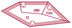
AIRSPACE CLASS A
|
|
Lower limits may be used if it results in a clearer presentation (i.e. “stacked” airspace). |
|
|
Upper limits omitted if at or above plane of division on a low chart. |
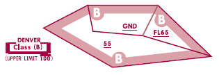
AIRSPACE CLASS B
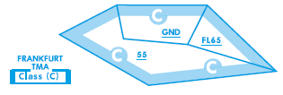
AIRSPACE CLASS C
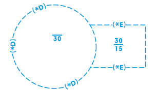
AIRSPACE CLASS D & E
Asterisk indicates hours of operation are not continuous. In such cases, operational hours will be tabulated elsewhere. Without asterisk hours are labeled H24.
|
|
Controlled airspace shown in white. Uncontrolled airspace shown as a tint. |
|
|
Controlled airway/route. |
|
|
Uncontrolled airway or advisory route. |
|
|
Radio Frequency Sector Boundary. |
|
|
Radio boundaries of control or service unit. |
|
|
Boundaries within TMAs or CTAs defining different altitude limits and/or sectors. |

