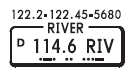
River Radio transmits on 114.6 and transmits and receives on 122.2, 122.45 MHz and HF frequency 5680.

River Radio ( RIV) guards (receives) on 122.1 and transmits through Canyon VOR on 113.9.
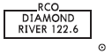
River Radio transmits and receives on 122.6 located at Diamond. Small circle enclosing dot denotes remote communication site.
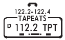
Tapeats Radio transmits and receives on 122.2 and 122.4. Telephone symbol indicates additional frequencies in communications panel listed under Tapeats.
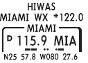
HIWAS — Hazardous Inflight Weather Advisory Service. Broadcasts SIGMETS, AIRMETS and PIREPS continuously over VOR frequency.
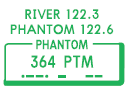
River Radio transmits and receives at Phantom on 122.3. Additionally, Phantom Radio transmits and receives on 122.6.

River Radio transmits through Lava VOR on 115.3, but is not capable of receiving transmissions through the VOR site.
![]()
Grand Radio is located at the airport and transmits and receives on 122.2 and 122.6. Additionally, Grand Radio provides LAA (Local Airport Advisory) on 123.6.
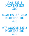
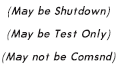
Terminal Radio frequencies and service may be included over airport or location name. Radio call is included when different than airport or location name. Mandatory Frequencies (MF), Aerodrome Traffic Frequencies ( ATF) or UNICOM (U) frequencies include contact distance when other than the standard 5 nm.
US “Enroute Flight Advisory Service”. Ident of controlling station to call, using (name of station) FLIGHT WATCH on 122.0 MHz. Charted above VORs associated with controlling station and remoted outlets. Service is not continuous.
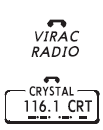
The telephone symbol indicates additional communications may be found in the communications tabulation after the associated NAVAID or location name. Telephone symbol does not necessarily mean that voice is available through the NAVAID.

Call and frequencies of Control Service for use within graphically portrayed Radio Frequency Sector Boundaries.
Call sign “CONTROL” and / or “RADAR” is omitted in all communication boxes in several regions.

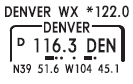
Plain language inflight weather station with name and frequency.
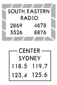
Call and frequencies of control or unit service. For use within geographically defined radio boundaries.

Call and frequency of enroute service or control unit. SINGLE SIDE BAND capabilities are available unless specified otherwise.
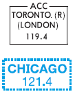
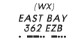
Remote air-to-ground antenna for direct communications with control center. Center is named in large type and name of remote site is in parentheses below followed by appropriate VHF frequencies.