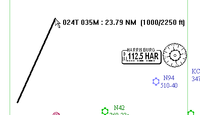
Use the electronic ruler to measure the bearing and distance between points on the enroute chart. The numbers at the end pointer position display bearing, distance and terrain elevation, as shown in the example below:
024T is the true bearing.
035M is magnetic bearing.
23.79 NM is the distance from the start to the end point.
1000/2250 feet indicates the approximate lowest and highest terrain elevations along the ruler.
To use the electronic ruler:
Point with the mouse to the starting location.
Hold down the SHIFT key, and then press and hold the left mouse button.
While holding down the SHIFT key, drag the pointer to the end point.
As long as you hold down the mouse button, you can drag the line anywhere in the chart view. The ruler line disappears when you let go of the mouse button.
| NOTE | To display the distance and terrain measurements in a different unit, click Tools > Options and change the Distance units on the Measurements tab. |