A Graphic Scale and a Terrain Legend are items available for display on the enroute chart. The Graphic Scale is a ruler that displays on the enroute chart to help you gauge distances at different zoom levels.
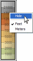
The Terrain Legend is available on the enroute chart when Terrain is selected on the Preferences toolbar.
| NOTE | The Terrain Legend is available only when terrain is selected during the installation procedure. |
To show (or hide) the Graphic Scale or Terrain Legend, right-click an open area of the enroute chart and select (or clear) Graphic Scale or Terrain Legend.
When the scale and legend appear on the enroute chart, you can also hide it by right-clicking the scale or legend and selecting Hide from the shortcut menu.
To move the Graphic Scale or Terrain Legend:
Point to the Graphic Scale or Terrain Legend.
When the four-way arrow appears, drag the Graphic Scale or Terrain Legend to a new location.
The Graphic Scale displays distance in nautical miles, statute miles or kilometers. The Terrain Legend displays elevation in feet or meters. To change the display unit, right-click the scale or legend and choose the preferred unit from the shortcut menu.
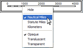
To change the appearance of the Graphic Scale, right-click the Graphic Scale, and choose Opaque, Translucent, or Transparent from the shortcut menu.