
SIGMETS — All current SIGMETS are depicted with solid YELLOW lines. The SIGMET name is depicted with a line pointing to the area. The start and expiration time of the SIGMET is depicted below the name, with the two digit day of month followed by the 4 digit hour and minute in UTC.
SIGMETs are issued for severe icing and turbulence, volcanic ash, tropical cyclones, and severe dust storms affecting an area of at least 3000 square miles for the U.S., Oceanic Areas and International FIR regions. Issued by the Aviation Weather Center in the U.S. and by state meteorological agencies internationally.
SIGMETs are issued as conditions warrant and valid for a 4-hour period for turbulence and icing, and for a 6-hour period for volcanic ash and dust, and tropical cyclones.
Convective SIGMETS — All current Convective SIGMETS are depicted with solid RED lines. The Convective SIGMET name is depicted with a line pointing to the area or line. The start and expiration time of the Convective SIGMET is depicted below the name, with the two digit day of month followed by the 4 digit hour and minute in UTC.
Convective SIGMETS are issued for severe thunderstorms, lines of thunderstorms at least 50 miles long where 40% of the length is affected by thunderstorms, and for active areas of thunderstorms at least 3000 square miles where 40% of the area is being affected by thunderstorms.
Convective SIGMETs are issued every hour as needed, and are valid for a 2-hour period. The Storm Prediction Center in Norman, OK, is responsible for issuing Convective SIGMETs in the U.S. and adjacent oceanic areas. Convective SIGMETs are issued for the Eastern, Central, and Western U.S.
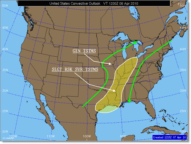
Convective Outlooks are forecasts of potential convective activity issued for a 4-hour period. An outlook is issued for a 4-hour period.