NEXRAD Radar is available only in the U.S.
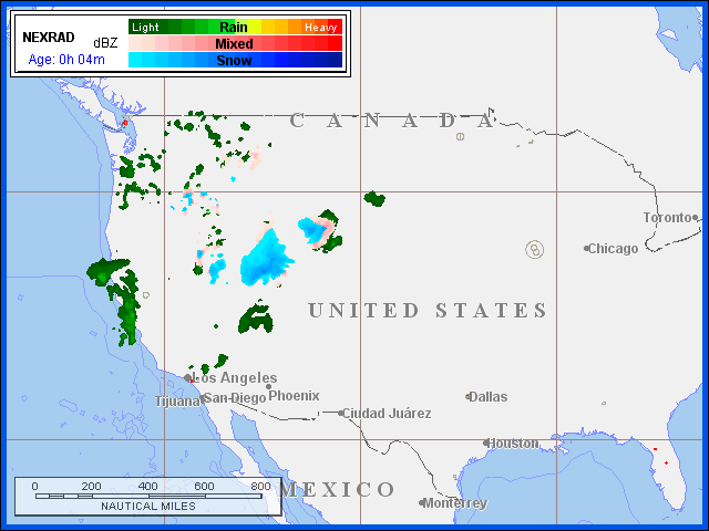
Three precipitation types, rain, mixed precipitation, and snow, are depicted using three distinct color palettes of 16 colors each to show increasing precipitation intensity.
NEXRAD Winter Radar Mosaics depict base reflectivity in unique color schemes so that you can easily differentiate between rain, mixed precipitation, and snow during winter months. A complex computer algorithm uses NEXRAD base reflectivity and identifies areas where snow, freezing rain, and mixed precipitation are falling. Rain is depicted using 16 colors ranging from dark green (light rain) to yellow (moderate rain) to dark red (heavy rain). Mixed precipitation or freezing rain is depicted using 16 colors ranging from light pink (light) to pink (moderate) to red (heavy). Snow is depicted using 16 colors ranging from light blue (light snow) to blue (moderate snow) to dark blue (heavy snow). The Jeppesen Winter Radar Mosaic maps are created for the entire U.S. as well as the six regional U.S. areas.
Maps are created every 6-10 minutes and contain the most recent NEXRAD information.

Echo tops are depicted with 16 colors from gray (surface) to purple (70,000 ft) that indicate the altitude in hundreds of feet of the maximum precipitation returns.
NEXRAD Echo Tops depict the height, in hundreds of feet, of the highest echo returns. Different colors are used at 5,000-foot intervals from the surface up to 70,000 feet. Echo Tops represent the tops of the actual precipitation, not cloud tops. Sometimes cloud tops can be higher than echo tops but do not contain precipitation. The Jeppesen Echo Top maps are national or regional mosaics which combine the information from individual radar sites.
Maps are created every 6-10 minutes and contain the most recent NEXRAD mosaic.