
MAPLE NEXRAD Forecast — 16 levels for three distinct precipitation types; rain, mixed precipitation, and snow are depicted using three distinct color palettes. Legend associates colors with intensity.
Severe Thunderstorm/Tornado Watch Areas — A yellow box indicates a Severe Thunderstorm Watch area. A red box indicates a Tornado Watch area. Watch areas represent areas where the conditions are favorable for the development of severe thunderstorms or tornadoes.
Airport Locations — Selected airport locations are indicated on the background map using the 4 letter ICAO identifier in white.
MAPLE NEXRAD Winter Radar Mosaic Forecast depicts base reflectivity in unique color schemes so that users can easily differentiate between rain, mixed precipitation and snow during winter months. The MAPLE computer algorithm uses NEXRAD base reflectivity and numerical model output to predict where radar base reflectivity will exist in the future. Output is available for a 6 hour period at 15 minute time intervals. New output is generated every 15 minutes based on updated NEXRAD base reflectivity and new model data every hour. Output identifies areas where snow, freezing rain and mixed precipitation are forecast to be.. Using distinct colors, users can identify various precipitation regimes. Rain is depicted using 16 colors ranging from dark green (light rain) to yellow (moderate rain) to dark red (heavy rain). Mixed precipitation or freezing rain is depicted using 16 colors ranging from light pink (light) to pink (moderate) to red (heavy). Snow is depicted using 16 colors ranging from light blue (light snow) to blue (moderate snow) to dark blue (heavy snow). The MAPLE Winter Radar Mosaic Forecast iscreated for the entire U.S. as well as the six regional U.S. areas.
Maps are created every 15 minutes for a 6-hour forecast period at 15 minute time intervals.
Echo Tops — 16 levels depicted with colors from gray (surface) to purple (70,000 ft) that indicate the altitude in hundreds of feet of the maximum precipitation returns. Legend associates colors with altitude of tops.
Severe Thunderstorm/Tornado Watch Areas — A yellow box indicates a Severe Thunderstorm Watch area. A red box indicates a Tornado Watch area. Watch areas represent areas where the conditions are favorable for the development of severe thunderstorms or tornadoes.
Airport Locations — Selected airport locations are indicated on the background map using the 4 letter ICAO identifier in white.
NEXRAD Echo Tops depict the height, in hundreds of feet, of the highest echo returns. Different colors are used at 5,000-foot intervals from the surface up to 70,000 feet. Echo Tops represent the tops of the actual precipitation, not cloud tops. Sometimes cloud tops are higher than echo tops but do not contain precipitation. The Jeppesen Echo Top maps are national or regional mosaics which combine the information from individual radar sites.
Maps are created every 6-10 minutes and contain the most recent NEXRAD mosaic.

1 Hour Precipitation Accumulation — 16 levels of precipitation accumulation are depicted using colors from light gray (0.1 inches) to white (10.0 inches). Legend associates colors with 1-hour precipitation accumulation.
Airport Locations — Selected airport locations are indicated on the background map using the 4 letter ICAO identifier in white.
NEXRAD 1-Hour Precipitation represents the cumulative inferred precipitation that has been measured over the past hour. Precipitation amounts are inferred, as they are not actually measured by the NEXRAD radar, but the reflectivity values are associated with precipitation rates, and thus cumulative precipitation is inferred. The precipitation is “measured” by determining the reflectivity values and duration for which they existed over an area. The color palette in the lower left corner associates different colors to the cumulative precipitation received over the last hour. The Jeppesen 1-Hour precipitation maps are national or regional mosaics which combine the information from individual radar sites.
Maps are created every 6-10 minutes and contain the most recent NEXRAD mosaic.

Precipitation Intensity — 6 levels depicted with colors from dark green (very light) to red (extreme) that indicate precipitation. Legend associates colors with intensity.
Echo Tops and Cell Movements — 3 digit underlined numbers represent the altitude of the precipitation at the dot connected to the base of the number. Altitude is labeled in hundreds of feet. Arrows indicate the direction of movement for individual cells. Speed of movement is indicated in knots at the tip of the arrow.
Severe Thunderstorm/Tornado Watch Areas — A yellow box indicates a Severe Thunderstorm Watch area. A red box indicates a Tornado Watch area. Watch box area depict areas that are favorable for the formation of severe thunderstorms and tornadoes.
Surface Fronts — Cold fronts are dark blue, warm fronts are red, occluded fronts are purple and stationary fronts are alternating red/blue. Surface Troughs are dashed purple lines.
High & Low Pressure Centers — Blue H represents the center of high pressure, and red L represents the center of low pressure.
Surface Freezing Line — Light Blue dotted line depicts the surface 0 degree Celsius isotherm.
Radar Signature Symbols:
Hail - Suspected hail locations are depicted by a purple triangle.
Tornado - Suspected tornado locations are depicted by a red inverted triangle.
Mesocyclone - Suspected mesocyclone (rotating thunderstorm) locations are depicted by a blue circle.
The Jeppesen Radar Composite map combines reflectivity values and echo tops as reported by the NEXRAD Radar Coded Messages (RCM). These reports are issued twice per hour at 20 and 50 minutes past the hour. Resolution of radar echoes is approximately 10km.
Maps are created every 30 minutes at the top and bottom of the hour.

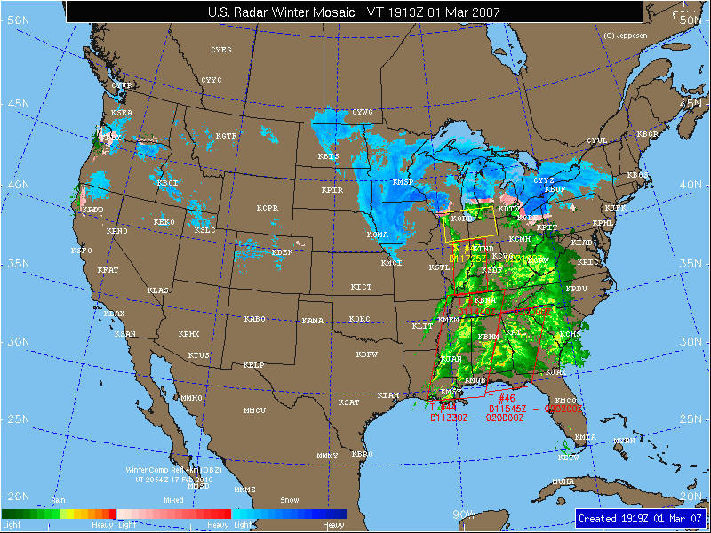
Winter Radar Mosaic — 16 levels for three distinct precipitation types; rain, mixed precipitation, and snow are depicted using three distinct color palettes. Legend associates colors with precipitation intensity.
Severe Thunderstorm/Tornado Watch Areas — Yellow box indicates a Severe Thunderstorm Watch area. A Red box indicates a Tornado Watch area. Watch areas represent areas where the conditions are favorable for the development of severe thunderstorms or tornadoes.
Airport Locations — Selected airport locations are indicated on the background map using the 4 letter ICAO identifier in white.
NEXRAD Winter Radar Mosaic depicts base reflectivity in unique color schemes so that you can easily differentiate between rain, mixed precipitation, and snow during winter months. A complex computer algorithm uses NEXRAD base reflectivity and identifies areas where snow, freezing rain, and mixed precipitation are falling. From these distinct colors you can identify various precipitation regimes. Rain is depicted using 16 colors ranging from dark green (light rain) to yellow (moderate rain) to dark red (heavy rain). Mixed precipitation or freezing rain is depicted using 16 colors ranging from light pink (light) to pink (moderate) to red (heavy). Snow is depicted using 16 colors ranging from light blue (light snow) to blue (moderate snow) to dark blue (heavy snow). The Jeppesen Winter Radar Mosaic maps are created for the entire U.S. as well as the six regional U.S. areas.
Maps are created every 6-10 minutes and contain the most recent NEXRAD information.
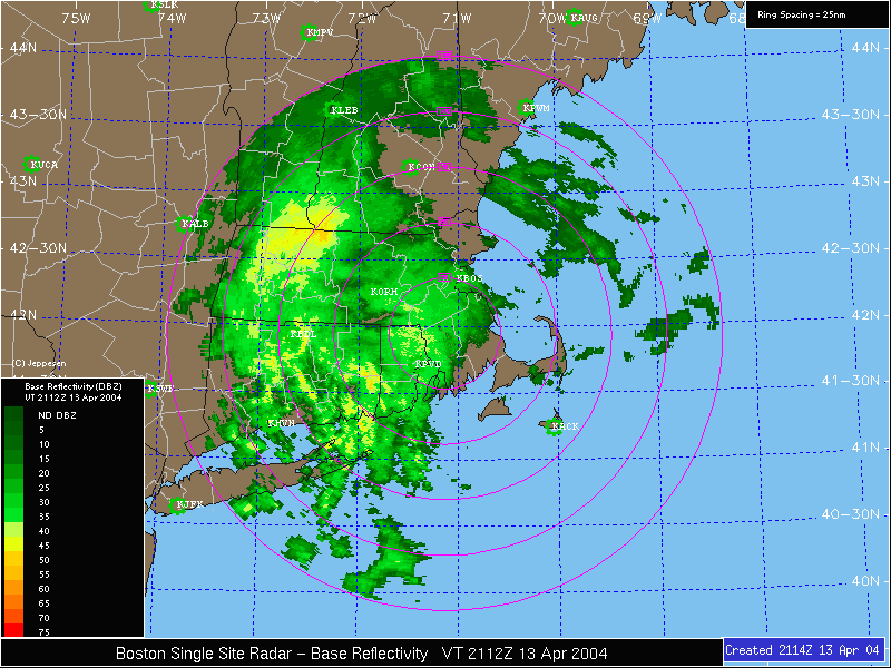
Single Site Base Reflectivity — 16 levels of precipitation depicted. Legend associates colors with precipitation intensity.
Airport Locations — Selected airport locations are indicated on the background map with a green airport symbol with the corresponding 4 letter ICAO identifier in white. State and county borders are also depicted with dark solid lines. Magenta range rings extend from the NEXRAD site 25 nm at intervals out to the maximum range of 125 nm. The resolution of the Base Reflectivity data is 1 km.
Single Site radar maps depict the actual base reflectivity from the individual NEXRAD radar sites. There are 156 radar sites operated by the NWS, FAA and DoD in the contiguous U.S., Alaska, Hawaii, Guam, and Puerto Rico. The sites are operated by radar operators and can be operated in two distinct modes; Precipitation Mode and looking at the legend on the map. Precipitation Mode legend is from 0 to 75 dBz, and Clear Air Mode legend is from -29 to 29 dBz.
Precipitation Mode — When precipitation is nearby or expected soon, the radar generally operates in Precipitation mode.
In this mode, the returns are generally in green with higher intensity precipitation in yellow, orange and red. The scale on the legend will run from 0 dBz to 75 dBz.
Maps are created every 6 minutes in Precipitation mode.
Clear Air Mode — When there is no precipitation nearby, the radar will generally operate in Clear Air mode. In this mode, the sensitivity of the radar is increased so that the radar will return energy from dust and insects, as well as detect inversions in the atmosphere.
Returns in Clear Air mode are generally yellow, orange, and red. The scale on the legend in Clear Air mode will run from -29 dBz to 29 dBz.
Maps are created every 10 minutes in Clear Air mode.