The Profile View optimization feature will help you select an altitude that results in the least time, fuel, or cost for the trip. FliteStar uses power settings, temperature, winds aloft, and aircraft performance figures to determine an appropriate altitude between the MEA and service ceiling of the aircraft which optimizes fuel consumption, time and/or cost for the segment selected. These calculations take into account the time to climb and descend and descent speeds and rates entered in the aircraft defaults information.
To optimize a route as you plan it (IFR and Corporate versions):
Open the Route Wizard.
In the third page, General Routing Information, check the last box, Get Winds.
Check the box that appears beneath it, Route Optimization for Winds.
Continue planning the route. FliteStar downloads current wind data from your default weather provider and calculates the most efficient route.
To optimize the altitude for an existing route:
Download a text weather briefing with Winds Aloft data.
Adjust power, temperature, and altitude prior to optimizing.
Open the Optimize dialog using one of the following methods:
In the Profile View, select specific route segments by clicking each individually, or select the entire route by right-clicking in a blank area of the Profile View and choosing Select All Segments. Right-click the highlighted segment or route, and choose Optimize Altitudes.
Right-click the route in the RoutePack List, and choose Optimize Altitudes.
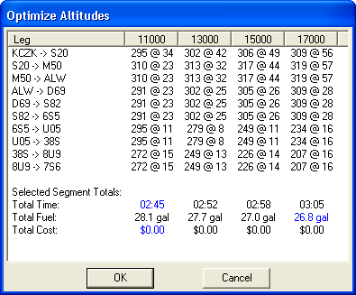
The Optimize dialog box appears, similar to the one displayed below, with the best performance options highlighted in blue.
Click the column heading to select the column for the desired altitude. Optimum choices, highlighted in blue for Time, Fuel and Cost, may be at the same or at different altitudes. From this table, it is easy to see the trade-offs for different altitudes and make the best choice for your mission.
Click OK.