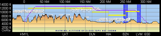
The terrain data shown in the FliteStar Profile View is depicted from left to right, from departure to destination. The profile window shows the approximate height of the terrain directly under the aircraft’s planned flight path.
In some cases the climb and descent paths shown on the profile view may intersect terrain. This is because FliteStar applies standard climb and descent performance profiles to the flight path in a straight line only.
| IMPORTANT | If terrain rises faster in a route segment than the aircraft performance can accommodate, it is up to you to adjust your planned flight path to assure adequate terrain separation. |
In the Enroute Charts View, zoom to view the section that you want to see. The Profile Window automatically adjusts to match the part of the route shown in the Enroute Charts View.
Right-click in the Profile View and choose Show Entire Route from the shortcut menu.
It is important to understand that no course width is used in the terrain depiction and lateral clearance from terrain will not be shown. In areas where terrain data is not known or the accuracy of that data is not acceptable, FliteStar will not depict any terrain in the profile window.
| CAUTION | Accuracy of terrain data varies greatly from region to region and should not be relied upon as the sole source of terrain clearance information for your planned flight. |