
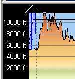
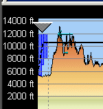
The profile window is a very powerful feature of FliteStar that displays a lot of information about your proposed route:
Height of the Terrain
Planned Climb, Cruise, and Descent Profiles
Distance along the route in nautical miles
MEAs (IFR and Corporate versions)
Winds Aloft (from the live Jeppesen Weather Service)
Weather Observations from the live Jeppesen Weather Service (winds aloft and icing areas) and METARs (clouds, thunderstorms, and precipitation - rain/mixed rain and snow/snow)
The flight profile is plotted from left to right and displayed as a purple line. the dotted line indicates climb and descent portions of the route.
The Profile pane top horizontal axis displays distances along the route. Route waypoint names are shown along the horizontal axis at the bottom, going from departure to destination left to right. Altitude increments are displayed along the left vertical axis.
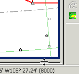
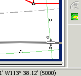
Terminal airspace is depicted by blue or purple shaded areas, and restricted airspace is shown in red. MEAs along airway routes are shown as yellow lines. When turn modeling is enabled, the gray shaded areas at waypoints indicate a change in route direction.
The light blue arrows indicate direction and strength of winds aloft. Areas of reported or forecast icing are depicted in turquoise blue. Cloud bases, precipitation, and thunderstorms are shown by icons.
The profile window will only be active when you have an actual route planned and displayed in the Enroute Charts View.
To view or hide the profile, do one of the following:
Click View > Profile or View > Remove Profile.
Click the Show/Hide
Profile button ![]() on
the Chart Toolbar.
on
the Chart Toolbar.
Drag up the window by moving the mouse pointer over the lower edge of the chart window until it changes to a double sided arrow:
Press the mouse button and drag the frame border up or down to reveal or hide the profile window.
To change the vertical axis or altitude scale of the profile window, move your mouse pointer over the top of the profile window just below the black border. The mouse pointer will change to a large arrow pointing up or down. Moving the pointer slightly up or down will change the direction of the arrow points.
To increase the profile vertical scale, click when the “up arrow” is displayed.
To decrease the profile vertical scale, click when the “down arrow” is displayed.
To reset the profile vertical scale, right-click in a blank area in the profile and choose Reset Height.
You can set the scale at the top of the Profile to show either Distance from Start (cumulative) or Distance to End (remaining) using the right-click menu.
To change the horizontal or nautical mile scale of the profile window, click and hold your mouse button down on one of the vertical graph lines and drag the line to the left or right. A small box will appear displaying the change. Release your mouse button to set the new display.
See Also:
Viewing Weather in the Profile