"Waypoint" is a generic term for an airport, VOR, NDB, intersection, or other navigational aid that can be used for defining a route. Included are User-Defined Waypoints and Route Waypoints.
In FliteStar, Start Descent and Level Off are altitude change points, but not waypoints. They are viewed in the profile window as a vertical red broken line or as an icon on the route in the Enroute Charts View. They will not appear on the RoutePack List and can not be modified.
Only Route Waypoints and User-Defined Waypoints can be moved.
To reposition waypoints on the map, click and drag the unlocked waypoint to a new location and drop it by releasing the mouse button.
To position a route or user-defined waypoint at an exact latitude/longitude:
Right-click a route or user-defined waypoint.
Choose Properties from the shortcut menu.
Type in an exact latitude and longitude. You may enter minutes and decimal seconds (example: 36.45 minutes) in the minutes field. FliteStar automatically converts the (.45) minutes to 27 seconds and fills in the seconds field.
To delete a waypoint:
Right-click the waypoint icon in the Enroute Charts View or on the RoutePack List.
Choose Delete from the shortcut menu.
Click Yes to confirm the deletion.
To open the Waypoint Properties dialog box:
Select the waypoint in the RoutePack List or on the Enroute Charts View (The waypoint highlights).
Right-click and choose Properties from the shortcut menu.
An airport, navaid or airway will display a different Properties dialog depending on the type waypoint selected. Nav aid information cannot be modified. See Displaying Chart Object Properties for additional information on Electronic Chart Data (NavData) Objects.
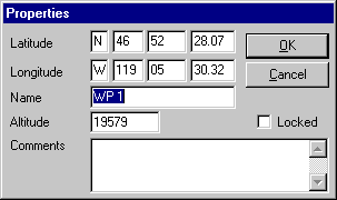
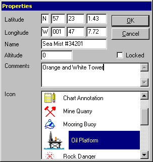
A route waypoint or user-defined waypoint, created either by manual routing or with the user-defined waypoint tool, can be modified through the Properties dialog box.
You may perform the following edits:
Name or rename the waypoint (a label that you can show or hide on the Chart).
Add comments for the waypoint (these do not display on the Chart).
Lock and unlock the waypoint. To lock a waypoint, select the Locked check box in the Properties dialog box. After it is locked, you will not be able to inadvertently move your waypoint. You can still open the Properties dialog box and move the waypoint by specifying new lat/lon coordinates. To unlock, clear the Locked check box.
Modify the latitude, longitude and altitude (in feet).
Below is the Properties dialog box that is displayed for Route Waypoints.

Below is the Properties dialog box for a User-Defined Waypoint. The only difference between Route and User-Defined Waypoints is that the User-Defined Waypoint icon can be modified by selecting a different icon from the list.
