Use the Display Filters tab to limit the airports and obstacles shown in the Enroute Charts View. To filter airports and obstacles displayed in the Enroute Charts View:
Right-click an open area in the Enroute Charts view, and choose Properties from the shortcut menu.
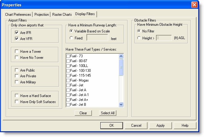
In the chart Properties dialog box, click the Display Filters tab.
You can filter airports according to characteristics and runway length as well as fuel and services. To
declutter the screen, FliteStar automatically hides some airports depending on the zoom level (scale) of the chart. The first airports to be hidden are those with smaller runway lengths. The enroute chart filters for airports described here does not affect airport filters set in the RoutePack List or Airport List.
The Only show airports that options display airports with the characteristics listed. More than one check box may be selected.
The Have a minimum runway length options display airports according to their runway length. Click either of the following:
The Variable Based on Scale option displays airports depending on the scale of the display. As you zoom in, more airports with shorter runways appear.
The Fixed option displays airports with a minimum runway length as entered. Any airport with a runway length less than that value does not display.
The Have These Fuel Types / Services section display airports with the fuel types and services that are selected. When no fuel types or services are selected, all airports appear (as other filters apply).
The airport filtering criteria in the Display Filters tab coordinate with the airport criteria in the Chart Preferences tab (also on the Properties dialog box) in the Nav Data category, as well as some of the buttons on the Preferences toolbar.
Airports displayed in the Enroute Charts View (and controlled by the Display Filters tab on the Properties dialog box) are from the Jeppesen Electronic Chart Data, while airports displayed in the Airport List are from your JeppView subscription. Airport filters on the Airport List do not determine the airports displayed in the Enroute Charts View.
Obstacle data is available in the VFR themes of the Enroute Charts View for reference only. You can display or hide them by clicking the Obstacle button in the Preferences toolbar. To set obstacle filters for those that have a measurement Above Ground Level ( AGL):
Right-click an open area in the Enroute Charts view, and choose Properties from the shortcut menu.
Click the Display Filters tab in the chart Properties dialog box.
In the Obstacle Filters section, click the Height radio button and enter the minimum altitude for obstacles that you want to see. The measurement will be in feet or meters depending on your distance measurement preference (Tools > Options > Measurement).
Click Apply to view the changes.
| CAUTION | The obstacle database is for reference only, and may not contain all obstacles or current height information. Be cautious around smaller airports where obstacle data might not be available. |
Some obstacles only display Mean Sea Level (MSL), and cannot be filtered.
For a description of obstruction symbology, see Obstacle Symbology.
See also: