FliteStar provides you with a variety of routing types. Although some are not available in FliteStar VFR, all options are available in FliteStar IFR and Corporate.
Direct routes follow the shortest path from departure to destination with no intermediate stops. You can add specific waypoints using the "Fuel Stops/Must-Fly Points" dialog box, or have FliteStar generate waypoints at set intervals by specifying a maximum leg length. FliteStar plots waypoints at that interval and shows their corresponding latitude/longitude in your flight plan and navigation log. To use navaid radials as waypoints check "Create RNAV waypoints". The navaid identifier, radial/DME and distance are included in your flight plan and navigation log.
If you use Jeppesen Weather, you can add RNAV waypoints along your route to get enroute winds aloft data. DUATS gathers wind data for a corridor along the route, while Jeppesen weather pulls data for individual points on the route.
GPS/Direct routing is quickly becoming the most useful and important type of auto-routing. With the availability of low-cost GPS units, pilots are increasingly filing IFR Direct and navigating along the great circle between their departure and destination. However, special use airspace, terrain, and many other types of obstacles often preclude flying along the great circle path. GPS/Direct routing determines the best path, independent of published waypoints, to avoid all specified obstacles.
VOR/NDB/Airport Routing plans a route using VORs, NDBs, and/or airports as navigation points. Since the legs are planned direct between fixes, FliteStar provides options in a later dialog box to route around various classes of airspace. You may select a maximum leg length for this route type also; the default is 250 nautical miles. FliteStar will not search paths that exceed the length you specify.
VOR/NDB/Airport Routing is similar to airway routing, the difference being that the waypoints of the network are the complete set of VORs, NDBs, and airports or any combination of the three. From any waypoint you can move to any nearby waypoint regardless of whether there is an airway segment along that path or not. This type of routing is very useful for VFR flight since airports are easily recognizable landmarks. Terrain and airspace avoidance are critical components in this type of auto-routing.
Available in FliteStar IFR and Corporate
Selecting this option will bring up another dialog box after Fuel Planning with specific options for airway routing. The airway type defaults to High or Low depending on the altitude you have chosen for the flight and the values you set under Tools > Options > Routing. Click on the drop-down menu at the top of the dialog box to override the default.
Airway routing is as its name implies: auto-routing through the high or low altitude airway network. This is the simplest type of routing since the network on which the algorithm operates is pre-defined. The ability to avoid airspace and terrain is not as important in airway routing, as the network is generally already free of these obstacles.
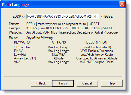
The plain language option takes direct input of waypoints and routing. Pilots often know exactly what clearances ATC will give them for certain routes. Since this may not be the most efficient in terms of distance or aircraft performance, FliteStar probably would not develop the same route.
Plain language is available only for routes with no fuel stops or must/fly points, and you must follow the formats shown in Plain Language Routing Syntax.
Although manually creating a route works well, there are many times, particularly when planning long, complicated routes, that you will want FliteStar to do most of the work. FliteStar contains a powerful routing system that can accurately and quickly calculate a route for you in seconds. To fully understand why FliteStar selects a particular route, it is helpful to have a background in how FliteStar operates.
FliteStar's auto-outing calculations use a Shortest Path algorithm which finds the best path through a virtual network. The network is composed of waypoints and the potential flight paths which connect the waypoints. There are three basic categories of shortest-path auto-routing possible in FliteStar: Airway Routing, VOR/NDB/Airport Routing, and GPS/Direct Routing. All of these types of routing are capable of avoiding many types of obstacles including special use airspace, specified FIR/UIRs, user defined boundaries, and terrain.
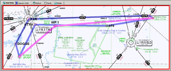
For Airway, VOR/NDB/Airport, and GPS/Direct routing, the cost of a particular path is usually a function of distance or fuel use, but can be infinite if the arc crosses one of the obstacles being avoided. The figure below shows a comparison of routes generated between the same pair of airports (KATA to 096) using each of the three categories. The airway route (top blue line) follows the airway path through DOGGE intersection and TXK VOR. The VOR/ NDB/Airport route (other blue line) never actually follows an airway, but uses two other airports as waypoints as it avoids the green MOA. The GPS / Direct route (pink line) generates a waypoint on the fly (WP1) at a location which allows it to avoid the airspace at minimal cost.