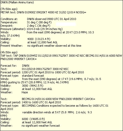
METAR symbols display in the Enroute Charts view when the Weather toolbar button is enabled and the Time Slider is set to a time when METAR data is available. Hover the cursor over a METAR symbol to view a tooltip.
METAR and TAF text is also visible in the Airport Properties dialog. Right-click any airport with a METAR symbol and select the Properties > Weather tab. If an airport icon is not displayed below the METAR icon, zoom in and/or enable Airports from the Preferences toolbar.
METARs (Aviation Routine Weather Reports) are available for airports worldwide. METARs are received and disseminated by the FAA and NWS in the U.S. and by state Air Navigation Service Providers and meteorological agencies internationally.
METAR observations are taken hourly, except when conditions warrant a special (SPECI) observation.
TAFs (Terminal Aerodrome Forecasts) are issued by local National Weather Service Forecast Offices (WFO) in the U.S. and by state meteorological agencies internationally.
TAF text displays in the Enroute Charts view METAR tooltips and in airport right-click Properties > Weather tabs.
TAFs are issued at 0000, 0600, 1200 and 1800 UTC and are valid for either a 24- or 30-hour period. TAFs can be amended, corrected, and suspended as needed.
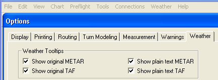
By default FliteStar shows both coded and plain text METARs and TAFs in the tooltip.
To hide the coded or plain text METARs or TAFs in the tooltips:
Open the Tools > Options > Weather dialog.
Uncheck the boxes for anything you do not want displayed in the tooltip, and click OK.