
The Nav Log is set up like a standard paper log and provides basic route data for each leg of your selected flight, including alternate airport information.
See Nav Log Fuel Calculations for explanations of the different fuel fields and how their values are derived.
The weather provider and time/date stamp of the data used for winds & temps is shown in the header, along with the date the report was printed and the NavData expiration date.
| NOTE | If the route was created in the past and the winds are no longer valid, right-click the route in the RoutePack list or Enroute chart and choose Re-Plan This Route (Wizard), use the Route Calculator to reset the start time, or download a new briefing. |
There are two ways to access the Nav Log:
Click Preflight > Reports > Nav Log.
Click the Reports tab and click on the Nav Log button.
Refer to the following table if you need to change any elements in the Nav Log. If the changes are not reflected immediately, refresh the screen by clicking another View and returning to the Nav Log.
If you need to: |
You will need to: |
Change the waypoints or the waypoint order. |
Change the route in the Enroute Charts view. |
Change the amount of fuel on board. |
Edit the trip weight and balance by clicking Preflight > Weight & Balance for [Route]. See Weight & Balance for more information. |
Change the fuel units. |
To change the fuel units for the aircraft used with the displayed RoutePack only, right-click the RoutePack in the RoutePack List and select Properties from the short-cut menu. Next to the Aircraft field, click Edit. Change the fuel units in the Aircraft Setup Information tab. This only changes the fuel units for the selected RoutePack. See Modifying and Adding an Aircraft Model in the RoutePack for more information. |
Change the aircraft used with the route. |
To change the aircraft used with the RoutePack only, right-click the RoutePack in the RoutePack List and select Properties. Select an aircraft from the Aircraft drop-down menu. This only changes the aircraft for your RoutePack. See Modifying and Adding an Aircraft Model in the RoutePack for more information. |
View wind information and temperature near all the waypoints. |
Create the route while online, or download a Standard Weather briefing from DUAT/S or Jeppesen WX. See Standard Weather Route Briefing. |
Know how the fuel is calculated for each part of the route leg. |
|
In the Navigation log, MORA is displayed in parenthesis under MEA. When an MEA is not present with a waypoint, FliteStar uses the Grid MORA where the waypoint resides. Grid MORAs provide an obstacle clearance altitude within a latitude and longitude grid block, usually one degree by one degree. On Jeppesen charts, all MORA altitudes which are 6000 feet or lower have an obstacle clearance of 1,000 feet. If the MORA altitudes are 7,000 feet or greater, the obstacle clearance is 2,000 feet.
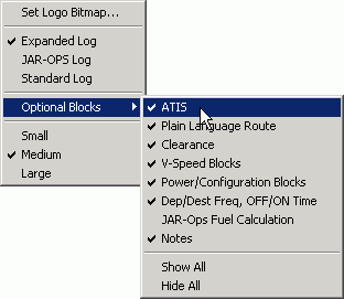
To bring up the shortcut menu, right-click anywhere within the Nav Log. The following options are available:
Click Set Logo Bitmap to select a corporate or personal logo to add to your navigation log.
Choose between Standard, JAR-OPS and Expanded forms.
Both the standard and expanded navigation logs can be customized to include the following options:
ATIS information
Departure and arrival frequencies
Plain language route briefings
Clearance
V-Speed Blocks (FliteStar Corporate Only)
Power/Configuration Blocks (FliteStar Corporate only)
JAR-Ops Fuel Calculation
An editable Notes block (not connected to the Notebook tab) that saves with the route.
Set the viewing size by clicking Small, Medium, or Large.
To customize the Nav Log report:
Right-click the Nav Log report and choose Optional Blocks from the shortcut menu.
Select or clear any items you want added to the report.
The Expanded Nav Log includes all the information in the standard Nav Log as well as columns for beginning and ending altitude, wind, outside air temperature (OAT), and power settings.
The JAR-OPS log includes options for Takeoff and Landing Data blocks, and the Notes block.
All Nav Logs have options to hide or show all blocks.
To add or remove the solid black headers in the Nav Log, go to Tools > Options > Printing tab, and select or clear the Use Black Headers in Printouts check box.
You can include a personalized or company logo in the header of the navigation log. Any standard bitmap of the format (.bmp) with a minimum size of 200 by 200 pixels can be used.
Right-click anywhere in the Nav Log and choose Set Logo Bitmap from the shortcut menu. A dialog box displays so you can search directories to find the bitmap file you wish to use.
After you locate the logo file, select it and click Open. The logo will be inserted at the top of your navigation log.
To remove an existing logo, right-click and choose Remove Logo from the shortcut menu.
To print the Nav Log, use one of the following printing options:
While viewing one of the reports, click File > Print > Print Report.
While viewing one of the reports, click the Print button in the Standard toolbar.
Click the Trip Kit button and select Nav Log under the Reports category. In the Nav Log drop-down menu, select Expanded Log, JAR-OPS Log, or Standard Log. Click Print or Print Preview.