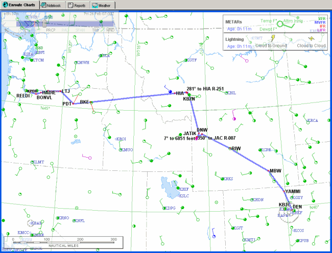
Once FliteStar completes your route, it is displayed in the Enroute Charts View. It should look similar to the route displayed below.
There are several different vector chart themes. To set the Low Altitude Enroute theme displayed below and add the Profile View to the bottom of your screen:
Right-click in a blank area of the chart and choose Vector Chart Themes.
Click Low Altitude Enroute.
Click View
> Profile or use the Profile button
![]() in the Chart toolbar.
in the Chart toolbar.
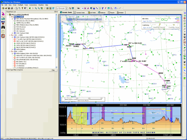
The RoutePack List displays the fixes for each leg of the flight. The legs of each flight are presented in a tree structure format so that you can see which routes are associated with each flight you plan.
Open the RoutePack List by clicking View > RoutePack List or pressing CTRL+L.
Click the first leg on the route list, KBJC->KJAC.
The segment turns a different color in the Enroute Charts View and the Profile View displays the terrain under that segment of the route.
You can add, delete or modify a route using the RoutePack List.
To add a new route:
Zoom in to an area of the chart so you can read the waypoint identifiers.
Right-click in a blank area of the RoutePack List and choose Add Route to [RoutePack Name].
Name the route (or select the default) and choose VFR from the drop-down menu. To exit the Route Properties dialog box, click OK. Your pointer will change to a waypoint symbol when you move to the Enroute Charts View.
Click at least four points on the chart to create a new route.
Right-click and choose Stop Appending Waypoints.
To delete a waypoint from the new route:
Scroll down the RoutePack List to view the new route.
Select the second waypoint.
To delete a waypoint, select it in the Enroute Charts View or RoutePack List and either press the DELETE key, or right-click and select Delete from the shortcut menu.
The route has been modified in the Enroute Charts View and the RoutePack List to reflect the change.
To search and add a waypoint to the new route:
On the RoutePack List, click on the second waypoint in your new route.
Right-click and choose Find/Insert Waypoint from the shortcut menu. The Search dialog box displays.
Look at the chart to find a waypoint you would like to add.
Enter the name or identifier in the Name field on the All Types Tab, or click the tab for a specific waypoint type, and enter the name or identifier.
Click Find.
Make sure the waypoint name is highlighted in the lower window and choose Insert to insert the waypoint above the second position or Append to add it at the end of the route.
The route has been modified in the Enroute Charts View and the RoutePack List to reflect the change.
To delete a route:
Select the route you created in the RoutePack List, or on the route itself in the Enroute Charts View.
Press the DELETE key or right-click to display the shortcut menu and choose Delete.
To adjust the cruise altitude from 12,500 feet to 14,500 on your route:
Click on one of the route leg names in the RoutePack List.
Move your cursor toward the top of the Profile View until it becomes an up arrow, and click to increase the altitude until you see 15,000 ft on the left side.
Right-click and choose Select All Segments from the shortcut menu. This selects the entire leg except the climb and descent portions.
Click and hold anywhere on the highlighted portion of the route and, while holding the left mouse button down, drag the line upward until you see 14,500 appear in a box to the left of the Profile View. Let go of the mouse button to reset the cruise altitude.
You can also adjust route altitudes using the Route Calculator.

There are several ways to change route waypoints. We will use the rubber-band method to alter the route. Suppose leaving Jackson you decide that you would rather go south to Alpine than over the pass. Use the following method to change the route waypoints:
Zoom into the KJAC area. Find U59, and place the mouse cursor above and to the left of it.
Hold down the left mouse button and drag the mouse to the right and down, until the blue outline box encloses the Dunoir VOR (DNW).

Now move the route line from Reed Memorial, U59, to Alpine, 46U.
Click on U59 to highlight it.
While the mouse is on U59, hold the left mouse button down and drag the red waypoint box down to Alpine. When the cursor and box are directly on top of Alpine, release the mouse button.

Your route now goes from Jackson to Alpine, and then north. FliteStar recalculates the profile, nav log, and all the performance data for the revised route.
To use the electronic ruler:>
Zoom out by clicking the
Zoom Out button ![]() on the
Chart
toolbar or by pressing the MINUS KEY until you can see the West Coast
of the United States.
on the
Chart
toolbar or by pressing the MINUS KEY until you can see the West Coast
of the United States.
Zoom in to the Portland, Oregon, area near the end of your route.
In the Preferences
toolbar, click the Terrain button ![]() .
.
Click the Terrain Contours
button ![]() .
.
Display the Electronic Ruler to find out how close you’ll fly to Mount Hood.
Hold the SHIFT key, point to a part of your route, and press the left mouse button.
Keep holding the SHIFT key and the left mouse button down, and move the mouse pointer down to the peak of Mount Hood.
In the illustration below, the ruler tells you that, from BONVL, the summit of Mount Hood is roughly 12.44 NM on a bearing of 133° true or 115° magnetic. The elevations along that line range from 3,300 feet to 10,100 feet.
If the ruler information is hard to read over the chart colors, choose Tools > Options > Display and change the Ruler Background Color. System Background Color works well over most themes.

To continue with the tutorial, see Getting Information About the Route.