Right-click on a chart object to obtain information about the route, surrounding airspace, navaids, and airports. For example, right-click anywhere on a route (except over a fix) and select Properties. The Route Properties dialog box provides you with basic information about your route.
You can also get to the Route Properties dialog box by right-clicking on a route in the RoutePack List and selecting Properties.
When a route is selected in the chart or RoutePack List, the Status Bar displays summary information about distance, fuel, and time.
To view information about a segment of the route:
Click the first waypoint of the segment
Hold down the keyboard SIFT key
Click the last waypoint of the segment
The information in the Status Bar changes to show the distance, fuel, and time for that segment.
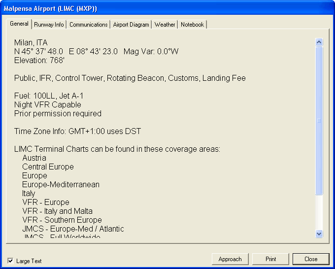
To retrieve airport information, right-click any airport in the RoutePack List, Airport List (JeppView feature) or on the enroute chart. You can view and print information about airports including runway information, local hotels, rental car information, and downloaded METARs. To resize the dialog box, click a corner with the cursor, hold the mouse button, and resize the dialog box. Click the Notebook tab to enter any notes.
To view the route in detail, click the Route Calculator button in the Quick Bar toolbar or click Tools > Route Calculator. You can adjust certain route parameters from the route calculator such as date, estimated time of arrival (ETA), winds, desired altitude, hard altitude, and power. Edit these fields by clicking on the field entry to be changed.

There are some parameters that can be edited and the new values applied to other parts of the route: Desired Leg Altitude, Power, Wind, Temperature. Right-click either the first or the last waypoint to be edited. A shortcut menu appears with the following options:
Click Fill Up to apply your edits to the entire route above this waypoint.
Click Fill Down to apply your edits to the entire route below this waypoint.
Click Fill Both to apply your edits to the entire route.
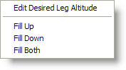
| NOTE | You can choose these options when editing Desired Leg Altitude, Power, Winds, or Temperature. Changes to the Date and ETA always affect the entire route. |
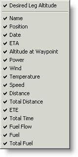
Right-click anywhere on the column header and select the columns to be displayed.
FliteStar generates the following reports each time you plan a flight:
Nav Log (choose either Expanded Log, JAR-OPS Log or Standard Log)
If you have the Corporate version of FliteStar, you have access to two additional reports: