When your computer is online, FliteStar begins downloading Jeppesen Weather Service information for your FliteStar NavData coverage area as soon as you open the program.
The out-of-the-box weather type overlays in the Enroute Charts view are:
NEXRAD Radar Winter Mosaic (U.S. only)
Surface Analysis Fronts
The other weather types available for overlay from the Weather toolbar are:
NEXRAD Radar Echo Tops
Surface Analysis Precipitation Accumulation and Forecast Accumulation
Winds Aloft
| NOTE | Live
weather overlays only display in the Mercator projection. If
you are not seeing any weather overlay while online, go to Preflight > Properties > Projection
and select Mercator from the drop-down list.
The Profile view wind, cloud, and icing area display is independent of the enroute map projection. |
Because some weather types require more data to display, some overlays appear sooner than others. The amount of time it takes for weather overlays to appear in the Enroute Charts view is directly related to Internet connection speed, as well as the geographic size of your NavData coverage area.
Download priority for weather types is based on:
· the Time Slider setting. For example, if you move the slider to the future, FliteStar changes download priority from current to forecast weather types.
· altitudes at and below the default or active RoutePack aircraft model service ceiling.
· the active Weather toolbar buttons. Weather types enabled in the toolbar are downloaded before types that are turned off.
A shaded area in the enroute chart indicates that some data for the covered region is in the process of being downloaded. One edge of the International Dateline is sometimes shaded for worldwide coverages.
When downloads for more than one weather type are in progress, and you're curious about which type is represented by the shaded area, toggle each of the enabled weather buttons off until you find the button that hides the shaded area. With slow connections there may be shaded areas for multiple downloads.
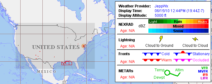
Click the Weather toolbar buttons to hide and show different weather product overlays in the Enroute Charts view. Hover the mouse over any button to see the name of the associated weather product.
| NOTE | When you move the Time Slider control, check that data is available for the weather type you want to see at the new slider position. Hover the cursor over the abbreviation below the timeline to view the times with available data for that type. |
Information for icing, turbulence, and winds aloft is given for altitudes from 0 up to 53,000 feet MSL. FliteStar downloads weather up to and including the active aircraft model service ceiling. If a route is selected, the RoutePack aircraft model is used. When no route is selected, the service ceiling of the default aircraft model is used.
In the Weather toolbar Set WX Altitude button dropdown list, the black dot marks the altitude of weather displayed in the chart. The selected display altitude is also shown in the Live Weather legend below the applicable product names, and in the Time Slider tooltips for those products.
To change the display altitude, click the Set WX Altitude button in the Weather toolbar. Click any level in the dropdown list to change the selection.
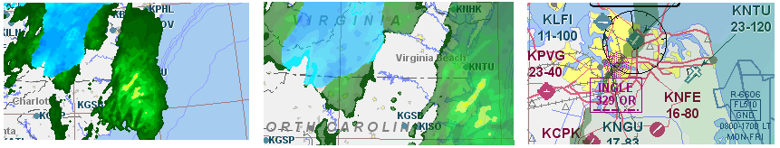
Certain aspects of the live weather overlays depend on how far in or out the chart view is zoomed.
RADAR, fronts, icing, and turbulence overlay transparencies on the chart automatically darken as you zoom out and lighten as you zoom in.
Go to the FliteStar Technical Support page at www.Jeppesen.com > Support > Technical Support > Industry - Aviation > FliteStar for additional Flash tutorials and other resources.
See also: